2005 Corn Maze
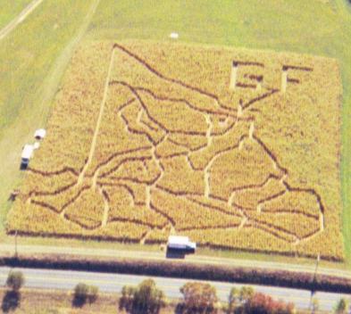
Tap or scroll mouse across picture for better maze viewing. If you see a star, tap or click to see the hint!
Following the local history theme, 2005 was the year we added clues and lazer lights to the maze. Our guests were challenged not only to find their way through the maze but to read the clues and figure out landmarks in Murrysville along with the significance of where these landmarks were situated in the design so they could then put the 17 clues in perspective and conclude that the maze was actually a very accurate map of Murrysville with significant roads and sites identified by the clues. The 17 clues provided were:
1.) CORN MAZE GATEWAY = GATEWAY TO WESTMORELAND C (the welcome sign recently erected as travelers heading East from Monroville on Rte. 22 will see upon reaching the Monroeville/Murrysville line.)
2.) EMERGENCY RESPONDERS = MURRYSVILLE VFD
3.) LARGE SIGN = MURRYSVILLE TREE SIGN
4.) FIRST IN NATION = HAYMAKER GAS WELL5.) HIKE HERE = DUFF PARK
6.) IGNORANCE COMPLEX = FRANKLIN REGIONAL SCHOOL CAMPUS
7.) NATURE RESERVE = KELLMAN NATURE RESERVE
8.) 1ST CHURCH = HILL’S CHURCH
9.) MCGRUFF’S BASE = POLICE STATION & MUNICIPAL COMPLEX
10.) MULTI-USE GREEN SPACE = TOWNSEND PARK
11.) EMRGENCY RESPONDERS = SARDIS VFD
12.) YOU ARE HERE (signified by a big red dot) = GEARHARD FARMS CORN MAZE
13.) FIRST RESPONDERS = WHITE VALLEY VFD
14.) INDIAN TRAIL = PUCKETY PATH
15.) FIRST RESONDERS = EXPORT VFD
16.) PAY TOLL HERE = NORTHERN PIKE TOLL HOUSE
17.) TEACHER’S HOUSE = STAYMATE’S LOG HOUSE
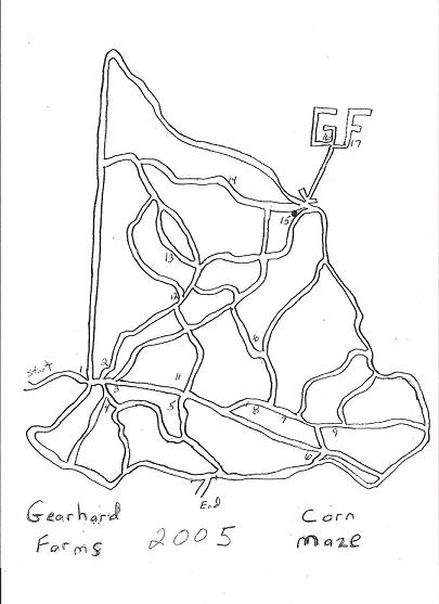
2005 Sketch
Back Home